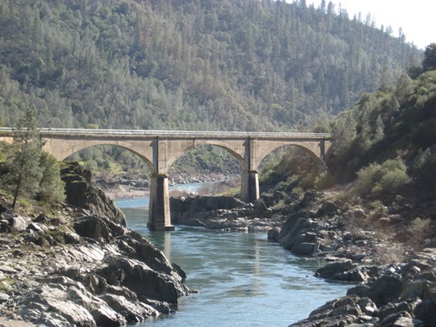
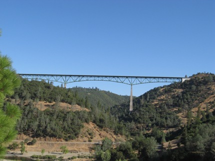
Cool is located approx 6.5 miles south of Auburn on Hwy 49 off interstate 80. The road is steep and winding but beautiful. You are actually driving through the Auburn Recreation Area, a State Park on the drive to Cool. You can view the Foresthill Bridge, (see below), when you get close to the confluence of the North and Middle forks of the American River. The Foresthill Bridge is the 4th highest bridge in the world, 3rd highest in the US (visit www.foothill.net/~andreaj/Bridge.htm for more information). The bridge has been used in several movies and commercials. You will also see "No Hands Bridge", a historic bridge, on your right side as you cross the river. "No Hands Bridge" is part of the current trail used by the Trevis Endurance Ride held every summer and is used daily by horses, pedestrians and bicyclists. You can learn more about No Hands Bridge, which was built in 1912, at www.co.el-dorado.ca.us/stories/nohands.html
No Hands Bridge
Cool is a small town with several stores including a gas station, grocery store, a tack & feed store and several restaurants all within walking distance from the Olmstead staging area. Many riders and hikers also stop in Cool for a bite to eat after riding/hiking at Cronin Ranch. For more information on Cool go to www.historichwy49.com/coloma/cool.html
Click on the staging areas listed under "Cool area" to view details of each staging area (ie: Olmstead, Cronin, etc). Staging areas are listed in the order they were added. Pictures of each staging area and the trails along with additional information can be found in the "Trail Pictures" section located to the left of this page.